

After record rainfall hit Canada’s west coast last week, Environment Canada has issued another weather warning for British Columbia this week. The Vancouver Island area will be getting hit with not one but two atmospheric rivers between this Wednesday, and the weekend. Atmospheric rivers are the same weather systems that hit the province a week ago, they bring in extremely large amounts of rain during very short periods of time, and so experts are pointing out that the saturated soil from last week’s storms could contribute to even worse flooding this time around.
Meteorologists are predicting between 40-80mm of precipitation for the city of Vancouver when the first weather system makes landfall on Wednesday, but there are heavier rains along the coast, close to Tofino, which could be getting 100-200mm of rain on the same day. Another problem to watch out for with these storms is that the freezing levels will be going up to 2,500m. What that means is that snow that is accumulated on mountains, and typically frozen at 1,000m, will now be subject to melting up to 2,500m of altitude, potentially worsening the flood-recovery efforts in the region. The second system that will be coming in during the weekend is expected to bring in mainly snow, which will be heavy around the Squamish and Whistler area.
As climate change becomes more and more evident for people across the country, BC and the government of Canada have taken notice, and Canada will become the first country in the world to develop a ranking system for atmospheric rivers. Environment Canada will be working on the system so that the government can better prepare citizens for when these weather systems are expected and to make it easier for evacuation and rescue efforts to take place.
Recovery work is still underway in the province as 4 people, and thousands of farm animals have died after heavy flooding and mudslides hit Vancouver Island and surrounding areas last week. Canadian astronaut Chris Hadfield shared a satellite image of the Lower Mainland and Vancouver Island region seen from space after the storms, and it became viral on social media as the extension of soil residue in the ocean is astonishing to see.
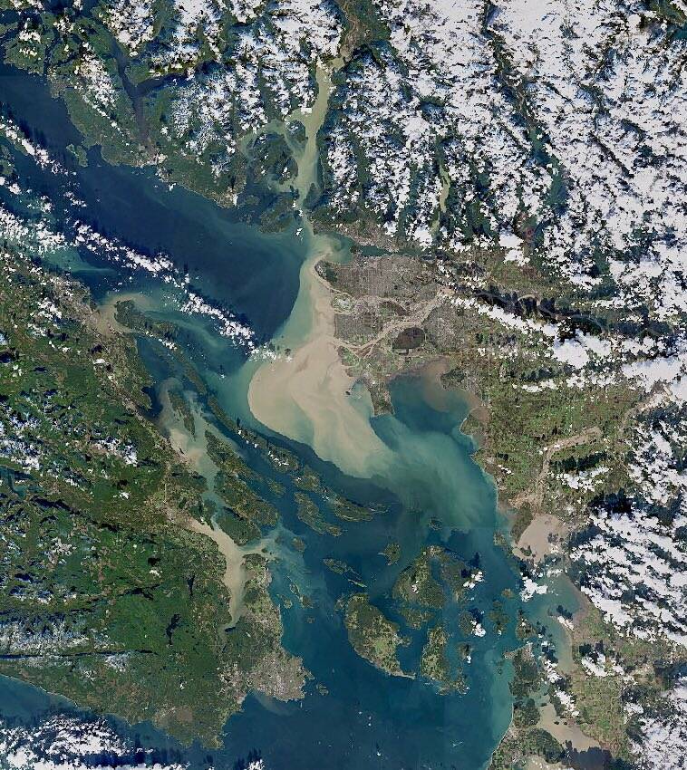
Courtesy of Chris Hadfield/Twitter
Lower Mainland and Vancouver Island seen from space after floodings, November 17, 2021.
Over the past few years, British Columbia has arguably been the most affected province in Canada by climate change, as devastating wildfires and heatwaves like the ones that killed an estimated 595 people in the province this year have constantly become worse with the progression of global warming. These specific events are another reason for concern over the weather systems coming into British Columbia this week. Experts point out that the more frequent heat waves and wildfires in the province have made the soil more susceptible to erosion and flooding, plus adding this up with the already saturated soil from last week’s storms, these atmospheric rivers could bring in a lot of damage. For that reason the government has asked residents of the province to prepare for more rainy weather. The biggest concern is that the rising freezing levels paired up with more storms could intensify mudslides and unstable riverbanks, potentially putting lives in danger.
For the full list of province warnings, access British Columbia’s government website, and for national weather warnings, take a look at Environment Canada.
Be the first to comment